
CURRENT ADVISORIES WIND ADVISORY – 10AM TO 10PM (CT & BERKSHIRES)
YOUR FORECAST:
TDY: RAIN, HEAVY AT TIMES AND WINDY. DAMAGING WIND GUSTS POSSIBLE.
50-55
TNTE: RAIN ENDS – PARTLY CLOUDY- DIMINSHING WIND – 45-50
TUES: CLOUDY, WINDY, SHOWERS – LOWER 50S
WED: PARTLY CLOUDY AND WINDY- MID 40S
THURS: SUN AND CLOUDS, BREEZY - 50
YOUR EVENING FORECAST:
TNTE: RAIN ENDS – PARTLY CLOUDY- DIMINSHING WIND – 45-50
TUES: CLOUDY, WINDY, SHOWERS – LOWER 50S
WED: PARTLY CLOUDY AND WINDY- MID 40S
THURS: SUN AND CLOUDS, BREEZY - 50
WEATHER TRIVIA:
1964- COLD WAVE SETS NEW NOVEMBER MARKS : -17 @ MINNEAPOLIS, -3 @ SPRINGFIELD, IL

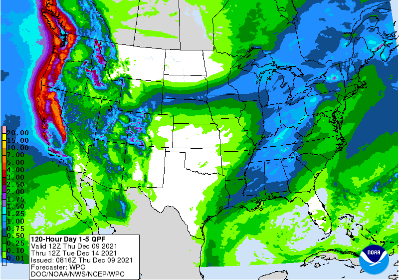
A large wet and windy storm climbs up the Appalachians today bringing heavy rain and wind from Carolinas to New England with possibility of damaging wind and even a tornado. Another storm hitting west coast could reach East coast this weekend. Below - today's threat of severe weather.....animated maps....and rainfall through Saturday.


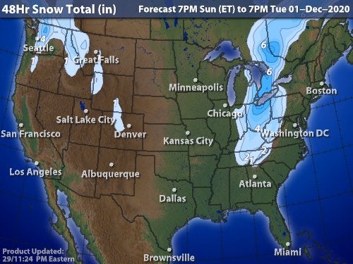
Below - snowfall map for next 48 hrs.

Your Robin Hood Radio Tri-State Forecast TODAY – PARTLY CLOUDY- LOWER 80S TONIGHT – CLEAR – MID 50S FRIDAY- SUNNY- LOWER 80S SATURDAY &...

Your Robin Hood Radio Tri-State Forecast TODAY – HAZY- HUMID – CHANCE OF A THUNDERSTORM – MID 80S TONIGHT – CLOUDY- SCATTERED THUNDERSTORMS –...

URGENT - WINTER WEATHER MESSAGE National Weather Service Albany NY 333 AM EST Wed Feb 23 2022 Northern Litchfield-Southern Litchfield-Northern Berkshire- Southern Berkshire-Western Greene-Eastern...