
TDY: WINDY WITH ANY RAIN CHANGES TO WET SNOW – LIGHT ACCUMULATIONS OF AN INCH OR TWO MAINLY IN HIGHER ELEVATIONS….35-40
TNTE: CLEAR AND COLD – MID 20S
SAT:SUNNY- MID 40S
SUN: CLOUDING UP FOLLOWED BY SHOWERS – MID 50S
MON: CHANGEABLE SKIWES – WINDY- PASSING RAIN OR WET SNOWSHOWERS – MID 40S
WEATHER TRIVIA:1844 - BUFFALO BARRACKS, N.Y. – 30” OF SNOW IN A 3 DAY STORM
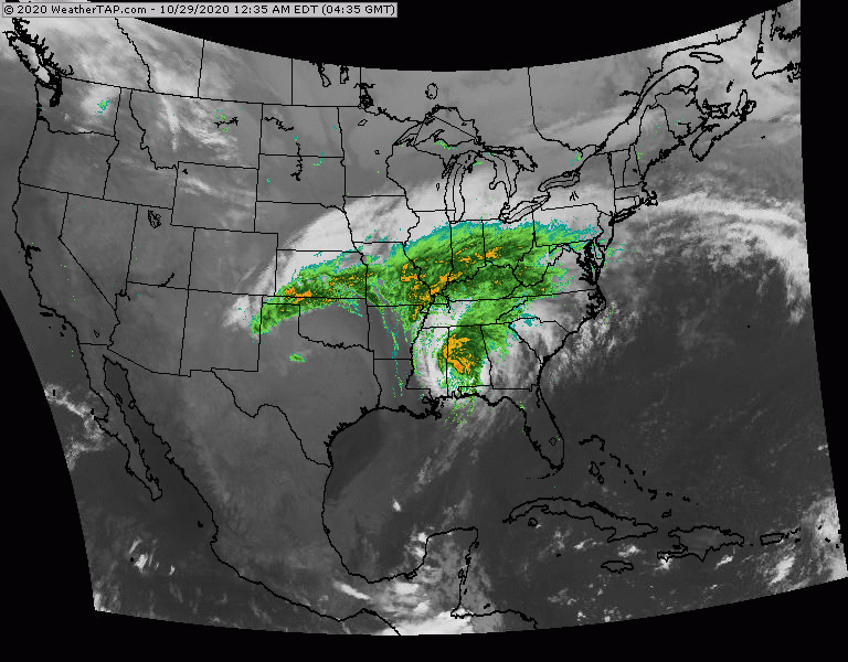
Above - satellite + radar shows Zeta moving out of Alabama...while winter storm is moving east out of Oklahoma. Rain from Zeta hits the Northeast today into tonight...Oklahoma storm hits Northeast Friday with some snow in New England.

Share this:TwitterFacebookEmailLike this:Like Loading...
CURRENT ADVISORIES HIGH WIND WARNING 6AM TO 6PM – CONN BERKSHIRESCATSKILLS – WIND ADVISORY 6AM TO 11PM YOUR FORECAST: TDY: DAMAGING WIND, RAIN, THUNDERSTORMS,...

TDY: CLOUDY- RAIN ARRIVING LOWER 50S TNTE: RAIN CHANGES TO WET SNOW WINDY LOWER 30S FRI: WET SNOW, 1”-3” BEFORE ENDING WINDY & CLEARING...