
YOUR FORECAST:TDY: HAZY- HUMID- SHOWERS AND GUSTY THUNDERSTORMS – MID 80S
TNTE: CLOUDY- SHOWERS AND STORMS STILL AROUND – LOWER 70S
FRI: PARTLY CLOUDY- HUMID, A SHOWER OR THUNDERSTORM – MID 80S
SAT: PARTLY SUNNY – MODERATELY HUMID – 85-90
SUN: HAZY- HOT-HUMID – LOWER 90S
WEATHER TRIVIA:1788- GEORGE WASHINGTON HURRICANE: CENTER PASSED RIGHT OVER MT. VERNON, N.Y. AS DESCRIBED IN HIS WEATHER DIARY.

Tropical Atlantic also heating up: Tropical Storm Gonzalo will become a hurricane now with 60-65 mph winds and will track toward Leeward Islands by weekend. Computers indicate weakening at that time...but it may only be temporary. Tropical depression in Gulf likely to become Hanna today and track toward the Texas Coast this weekend. Quite a problem since that state has a Covid problem...and shelters will only complicate matters. Below - tracks for these storms.


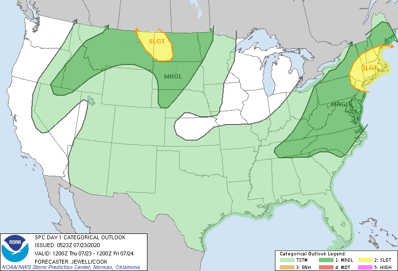
Below - today's satellite + radar showing more storms headed from Ohio Valley into the Northeast which may be severe.

Below - animated maps for next 2 days....severe weather for today - rainfall through Tuesday.


Lastly - snapshot weather for Friday.
BE SAFE!


Your Robin Hood Radio Tri-State Forecast TODAY – PARTLY SUNNY – MID 60S TONIGHT – CLEAR – 40-45 FRIDAY – SUNNY – 60-65 SATURDAY...

Your Robin Hood Radio Tri-State Forecast TODAY – TURNING PARTLY SUNNY – 85-90 TONIGHT – CLEAR- MID 60S SATURDAY – HAZY AND HUMID –...

Share this:TwitterFacebookEmailLike this:Like Loading...