
YOUR FORECAST:
TDY: SUN AND CLOUDS – MID 80S
TNTE: PARTLY CLOUDY – 60-65
SAT: PARTLY SUNNY – LESS HUMID – BREEZY - 80-85
SUN: SOME SUN WITH INCREASING CLOUDS, SHOWERS ARRIVING – 70-75
MON: SHOWERS – LOWER 80S
WEEKEND WEATHER INDEX IS A 5 OUT OF A PERFECT 10 !
WEATHER TRIVIA:1936 – KANSAS CITY HITS IT’S HOTTEST TEMP. EVER : 113F

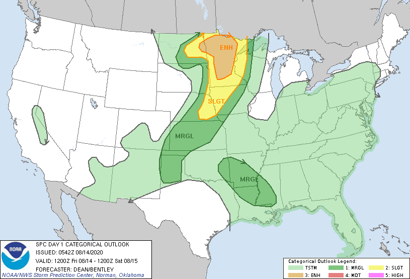
Satellite - radar above - watching a low over N.Carolina. It will move into Atlantic and could become tropical over weekend and bring gusty winds and some rain to Mid Atlantic Coast. Severe storms from No. Rockies to Upper Midwest today where some tornadoes are possible. Below - animated maps - today's severe weather - rainfall through Tuesday.


ODAY – CLOUDY WITH SHOWERS – LOWER 50S TONIGHT – SHOWERS END – WINDY – 35-40 TUESDAY – SUNNY- WINDY - 45-50 WEDNESDAY –...

WINTER WEATHER ADVISORY REMAINS IN EFFECT UNTIL NOON EDT TODAY… * WHAT…Snow. Snow accumulations of 2 to 5 inches are expected. * WHERE…Litchfield County...

Your Robin Hood Radio Tri-State Forecast TODAY – PARTLY SUNNY- MID 80S TONIGHT – PARTLY CLOUDY- MAYBE A SHOWER - 70 THURSDAY – HAZY-...