
YOUR FORECAST:
TDY: PARTLY SUNNY – LESS HUMID – MID 80S
TNTE: PARTLY CLOUDY- MID 60SFRI: SUN AND CLOUDS – MID 80S
SAT: PARTLY SUNNY – LESS HUMID – 80-85
SUN: SOME SUN WITH INCREASING CLOUDS - 80
WEATHER TRIVIA:1955- HURRICANE CONNIE HITS NO.CAROLINA WITH 83 MPH WINDS AND 6 TORNADOES.

Radar- satellite above show a noisy map with areas of showers and thunderstorms from coast to coast. Temps will cool off in Northeast...but over weekend..there will be a wind...and rain will return there Sunday. Below - animated maps....today's severe weather threat ....rainfall projection through Monday.


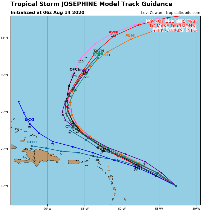
Below - hurricane center and model tracks of tropical depression which should become Josephine today.

Lastly - snapshot weather for Friday. Be safe.


WEATHERCAST: A COOL FRONT OVER OHIO WILL MOVE ACROSS THE REGION THIS EVENING. AHEAD OF IT…CLOUDS AND SOME SHOWERS. CLEARING COMES IN LATER TONIGHT...
YOUR FORECAST: TDY: PERIODS OF RAIN OR FREEZING DRIZZLE – 40-45 TONITE: PARTLY CLOUDY – 30 - MIDNIGHT TEMP: 32 WED: SUN AND CLOUDS...

Your Robin Hood Radio Tri-State Forecast TODAY – SOME SUN, SHOWERS AND STORMS DEVELOPING – 70-75 TONIGHT – SHOWERS END – 60-65 FRIDAY –...