
YOUR FORECAST:
TDY: CLOUDS AND SUN – LESS HUMID – MID 70S
TNTE: CLEAR- COOL – 45-50
SAT: SUNNY – MID 70S
SUN: CLOUDY- RAIN ARRIVING – 70-75
MON: PARTLY SUNNY - 80…
WEATHER TRIVIA:1942 – SEVERE SQUALL LINE ACROSS MINNESOTA - 70MPH WINDS – 11/2 MILLION IN DAMAGES.
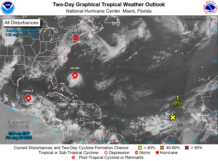
Above - satellite picture of the Atlantic Basin. It is peak hurricane season and this map tells it all. Paulette likely to become a hurricane and hit Bermuda Monday as a Cat 2. Rene....moving slowly west....needs to be watched and system off African coast likely to be named Sally as it heads east. Below - tracks for Paulette and Rene.


Below - animated maps for next 2 days - current satellite + radar map - rainfall through Tuesday.


 PHOTO OF BEAR AT DUMPSTER SITE AT LAKE WHERE PAT'S COTTAGE IS!
This Hazardous Weather Outlook is for the Taconics, the Berkshires, northwestern Connecticut and southern Vermont. Tuesday through Sunday: Widespread showers and thunderstorms are expected...

Your Robin Hood Radio Tri-State Forecast TODAY: EARLY SHOWERS, PARTLY SUNNY – LOWER 60S AFTER 9AM PARTLY SUNNY – LOWER 60S TONIGHT: PARTLY CLOUDY-...
ADVISORIES: FLOOD WATCH LATE THURSDAY NIGHT THROUGH LATE FRIDAY NIGHT// WIND ADVISORY 1AM TO 11AM FRIDAY FOR BERKSHIRES.WEATHER TRIVIA:1942 – COLD MADE MORE BITTER...