
TDY: CONSIDERABLY CLOUDY WITH SHOWERS – 75-80
TNTE: RAIN…LOCALLY HEAVY – MID 60S
WED: RAIN TAPERING DOWN….70
THURS: SHOWERS -70-75
FRI: PARTLY CLOUDY, SCATTERED SHOWERS – 65-70
WEATHER TRIVIA:1927- LATE SEASON TORNADO OUTBREAK IN MIDWEST: 72 DEATHS IN ST. LOUIS & WIDESPREAD DAMAGE FROM OKLAHOMA TO INDIANA.

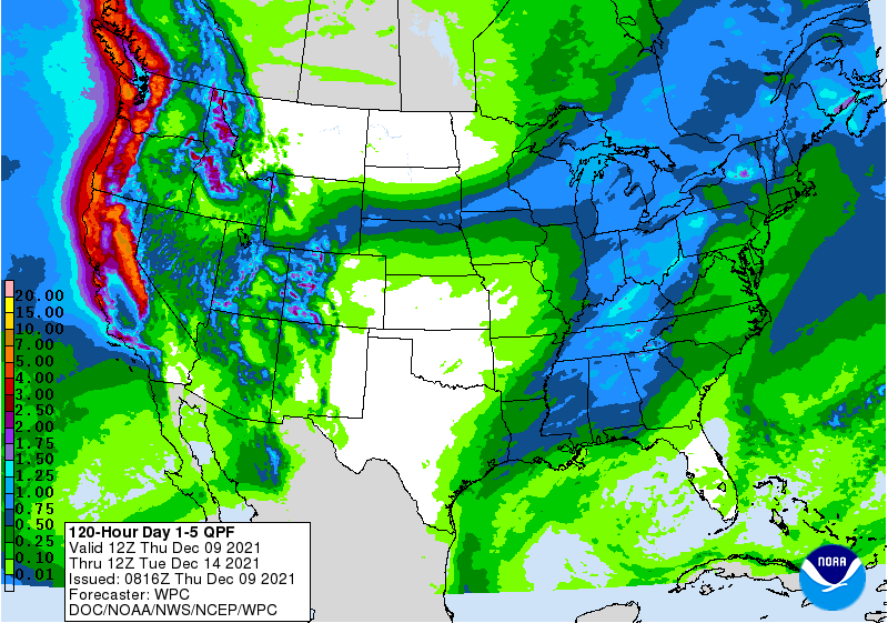
Satellite + radar above tell the story. Jet stream digging south across the Plains ejecting moisture north up the East Coast and Across the Great Lakes. This all spells heavy rain for the Eastern half of the Nation. Meanwhile getting very warm again out west....as it gradually cools down with the rain in the east. Below.....animated maps....severe weather threat for today and rainfall through Friday.


Below - latest Atlantic tropical map + snapshot weather for Tuesday.


Cool West & North….Summer Elsewhere Satellite and radar shows heavy thunderstorms in Western Plains..otherwise quiet. You can see the latest tropical storm in the...
WEATHER TRIVIA: 1936 – KANSAS CITY, MO., HITS ITS HIGHEST EVER – 113F. WEATHER-CAST SHORT VERSION: TDY: SUN & CLOUDS – MODERATELY HUMID WITH...
Share this:TwitterFacebookEmailLike this:Like Loading...