
TDY: SUN AND CLOUDS, HUMID, CHANCE OF A SHOWER – 80
TNTE: CLOUDY- MID 60S
TUES: CONSIDERABLY CLOUDY WITH SHOWERS – 75-80
WED: SHOWERS, CHANCE OF THUNDERSTORMS – LOWER 70S
THURS: SHOWERS TAPER DOWN – 70
WEATHER TRIVIA: 1985- HURRICANE GLORIA MAKES LANDFALL ACROSS LONG ISLAND, N.Y. CASINOS AT ATLANTIC CITY, N.J. EVACUATED.

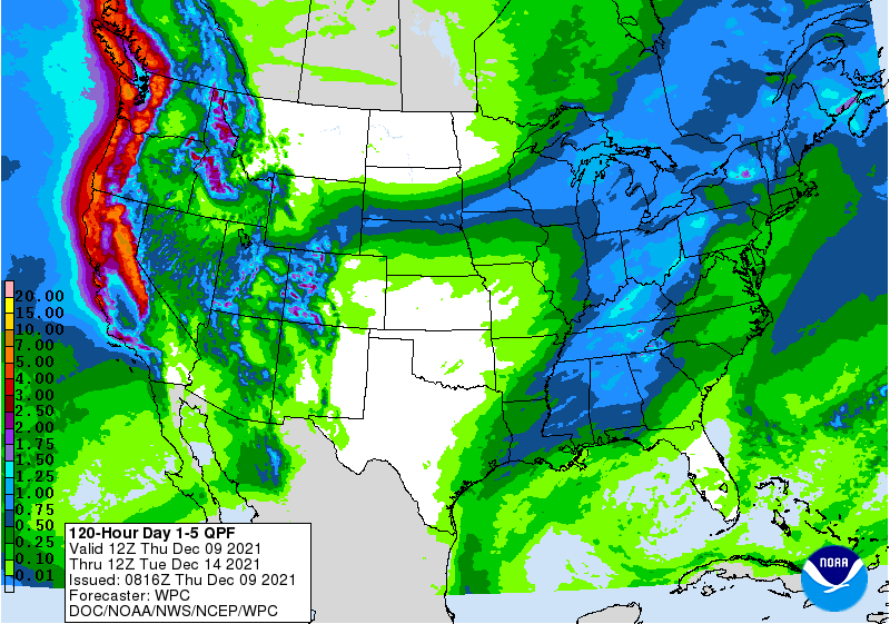
Satellite + radar above tell the story. Jet stream digging south across the Plains ejecting moisture north up the East Coast and Across the Great Lakes. This all spells heavy rain for the Eastern half of the Nation. Meanwhile getting very warm again out west....as it gradually cools down with the rain in the east. Below.....animated maps....severe weather threat for today and rainfall through Friday.


WEATHERCAST: SUNSHINE WITH A DRY NORTHWEST GUSTY WIND TODAY WILL BRING TEMPS WELL INTO THE 70S. CLEAR AND DRY TONIGHT- GOOD SLEEPING WEATHER –...

Your Robin Hood Radio Tri-State Forecast TDY – CONSIDERABLY CLOUDY, BREEZY – 50 TNTE – CLOUDY- LOWER 30S THURS – CLOUDY- RAIN DEVELOPING –...
YOUR FORECAST: TDY: CHANGEABLE SKIES AND WINDY – PASSING FLURRIES – MID 30S TNTE: CLEAR AND VERY COLD – 10 TO 15 THURS: SUNNY...