
YOUR DAYTIME FORECAST:
TDY: CLOUDY- SOME RAIN – 45-50
TNTE: CLEAR – MID 30S
SAT: MOSTLY SUNNY – 50-55
SUN: SUN MIXING WITH CLOUDS, WINDY, LATE SHOWERS – MID 50S
MON: SHOWERS THEN SOME SUN AND BLUSTERY - 50
YOUR EVENING FORECAST:
TNTE: CLEAR – MID 30S
SAT: MOSTLY SUNNY – 50-55
SUN: SUN MIXING WITH CLOUDS, WINDY, LATE SHOWERS – MID 50S
MON: SHOWERS THEN SOME SUN AND BLUSTERY - 50
WEATHER TRIVIA: 1946- INITIAL CLOUD SEEDING EXPERIMENT WITH DRY ICE: 4 MILE CLOUD CONVERTED TO FLURRIES IN THE BERKSHIRES, MA.

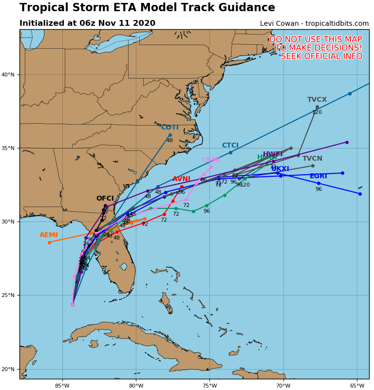
ETA - 65 mph winds - will head for west coast of Florida - between Cedar Keys and Clearwater today. After that it will rapidly northeast and merge with a cold front and pass off the SE Coast....into the Atlantic. Below - track by Hurricane Center and models....and a look at Atlantic basin map.


Today: Scattered showers and thunderstorms, mainly after 5pm. Patchy fog before 7am. Otherwise, partly sunny, with a high near 78. Calm wind becoming southeast...
Your Robin Hood Radio Tri-State Forecast TNTE: CLEAR – MID 60S THURS: PARTLY CLOUDY - MID 80S FRI: SOME SUN – SCATTERED SHOWERS &...

Your Robin Hood Radio Tri-State Forecast TODAY – SHOWERS TAPERING OFF, PARTLY CLOUDY – LOWER 70S TONIGHT– CLEAR- LOWER 50S SATURDAY – PARTLY SUNNY...